SEMA News Release
FOR IMMEDIATE RELEASE
March 26, 2025
Latest data shows minimal changes for most of the Lake of the Ozarks from current effective floodplain map; release of data marks beginning of review and comment period
The State Emergency Management Agency (SEMA) today released the latest flood risk data collected as part of its multi-year floodplain mapping project for the Osage River Watershed in Missouri. The Lake of the Ozark counties of Benton, Camden, Miller and Morgan counties are included in the study area. SEMA said the new data set, which accounted for the lake’s depth, storage capacity and water flow dynamics, showed minimal changes for most of the lake compared to the currently adopted effective maps.
“The bathymetry data, which provides a description of the underwater terrain and was the latest data added into our modeling, was the key part of the process that very significantly lowered flood elevation levels for the vast majority of areas around the lake that are occupied by residential, retail and commercial structures,” SEMA Director Jim Remillard said.
The initial flood risk data did not fully account for the lake’s characteristics, causing elevations in some areas to be overestimated by several feet. Input from local officials and community members on this initial data set led to additional flood risk data collection and modeling. By incorporating the lake’s bathymetry, the latest results now show elevations dropping by several feet compared to the previously shared data. Some areas may be only slightly higher than the elevations on the currently effective maps (Camden, Miller and Morgan counties adopted their maps in 2018; Benton County adopted its map in 2009), while others may experience a more significant increase.
The updated flood risk data is available online here. A user guide is available is here. While the website allows users to make comments directly, those impacted by the updated flood risk data are encouraged to reach out to their local floodplain administrator to discuss concerns and explore their options.
SEMA is in the process of taking into account existing Letters of Map Amendments (LOMA) related to the new dataset. Property owners with an existing LOMA do not need to apply for a new one if the lowest point of the lot or lowest adjacent grade documented in their LOMA remains above the proposed 1% annual chance water surface elevation in the updated flood risk data.
Additionally, all existing Letters of Map Change (LOMC) will undergo a validation process known as the Summary of Map Actions (SOMA) to determine whether they will be upheld or superseded based on the proposed flood risk data.
SEMA representatives began meeting with local floodplain managers and elected leaders in Benton, Morgan, Miller and Camden counties on March 25 to discuss the latest data and seek their input as part of the Federal Emergency Management Agency (FEMA) process.
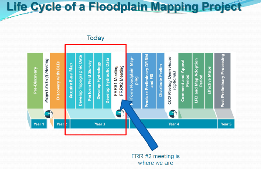
FEMA is providing a public comment period that is open through May 12. This step serves as a key opportunity for community officials, stakeholders and others to provide feedback and refine the updated flood risk data before the project advances to the next phase: floodplain mapping.
Once the floodplain mapping phase is complete, the public will have an additional opportunity to provide further input during the 90-day Public Comment and Appeal period, where residents can review the preliminary Flood Insurance Rate Maps (FIRMs) and submit comments or appeals supported by technical data.
Local input is essential in developing accurate and reliable flood risk data. SEMA appreciates the participation of those who have contributed to this process. This engagement helps ensure the accuracy of flood risk information, ultimately supporting better floodplain management and hazard mitigation planning. SEMA looks forward to continued collaboration as we move through each phase of the project.
The graphic below shows the progression of the multi-year floodplain mapping project for Benton, Camden, Miller and Morgan counties.

For more information, call 573-751-6294 or e-mail katy.linnenbrink@sema.dps.mo.gov
